


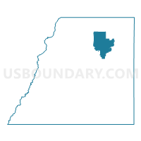
Douglas 105, Douglas County, Colorado
About
Outline

Summary
| Unique Area Identifier | 547653 |
| Name | Douglas 105 |
| County | Douglas County |
| State | Colorado |
| Area (square miles) | 25.88 |
| Land Area (square miles) | 25.88 |
| Water Area (square miles) | 0.00 |
| % of Land Area | 100.00 |
| % of Water Area | 0.00 |
| Latitude of the Internal Point | 39.46001410 |
| Longtitude of the Internal Point | -104.82827040 |
Maps


Graphs
Select a template below for downloading or customizing gragh for Douglas 105, Douglas County, Colorado


Neighbors
Neighoring Voting District (by Name) Neighboring Voting District on the Map
- Douglas 107, Douglas County, CO
- Douglas 109, Douglas County, CO
- Douglas 112, Douglas County, CO
- Douglas 118, Douglas County, CO
- Douglas 119, Douglas County, CO
- Douglas 134, Douglas County, CO
- Douglas 137, Douglas County, CO
- Douglas 138, Douglas County, CO
- Douglas 145, Douglas County, CO
- Douglas 147, Douglas County, CO
- Douglas 52, Douglas County, CO
- Douglas 62, Douglas County, CO
- Douglas 64, Douglas County, CO
- Douglas 65, Douglas County, CO
- Douglas 67, Douglas County, CO
Top 10 Neighboring County Subdivision (by Population) Neighboring County Subdivision on the Map
- Sedalia CCD, Douglas County, CO (141,391)
- Parker CCD, Douglas County, CO (103,753)
- Castle Rock CCD, Douglas County, CO (40,321)
Top 10 Neighboring Place (by Population) Neighboring Place on the Map
- Castle Rock town, CO (48,231)
- Parker town, CO (45,297)
- The Pinery CDP, CO (10,517)
- Castle Pines North city, CO (10,360)
- Castle Pines CDP, CO (3,614)
Top 10 Neighboring Unified School District (by Population) Neighboring Unified School District on the Map
Top 10 Neighboring State Legislative District Lower Chamber (by Population) Neighboring State Legislative District Lower Chamber on the Map
Top 10 Neighboring State Legislative District Upper Chamber (by Population) Neighboring State Legislative District Upper Chamber on the Map
Top 10 Neighboring 111th Congressional District (by Population) Neighboring 111th Congressional District on the Map
Top 10 Neighboring Census Tract (by Population) Neighboring Census Tract on the Map
- Census Tract 140.12, Douglas County, CO (7,440)
- Census Tract 141.22, Douglas County, CO (6,572)
- Census Tract 139.08, Douglas County, CO (6,306)
- Census Tract 145.03, Douglas County, CO (5,592)
- Census Tract 140.06, Douglas County, CO (5,205)
- Census Tract 139.07, Douglas County, CO (4,596)
- Census Tract 140.13, Douglas County, CO (3,742)
- Census Tract 141.23, Douglas County, CO (3,087)
- Census Tract 141.25, Douglas County, CO (2,579)
- Census Tract 140.11, Douglas County, CO (1,692)